
From City to Sea by Kayak
Due to a change in circumstances this year, not entirely arising from Covid-19, Jenny Ball has been able to revisit favourite water side haunts or undertake new trips afloat that previous work and sailing commitments would not have permitted.
One such trip that she would recommend to you – either as a walker or on a kayak or SUP – is the wonderful Chelmer and Blackwater Canal. A most beautiful and scenic route, right in our back yard and, until this summer, largely undiscovered. You can walk and paddle the entire length from Chelmsford to Heybridge Basin and both the waterway and footpath are clear and well maintained.
In September, Jenny extended the trip by continuing beyond the end of the canal at Heybridge Basin all the way to Bradwell Waterside. A journey that cargo would have regularly taken via sailing barges and lighters for over 170 years. But those crews probably did not stop for a slap up lunch or glasses of wine, like she was able to. And they probably would not have rated my craft very highly – an inflatable kayak or “paddling pool” as one of the Bradwell Watersiders called it. Quite uncharitably, she thought. I will let Jenny tell the tale of her adventures.
The History of The Chelmer and Blackwater Canal
So a quick history lesson. The Chelmer and Blackwater Canal was opened in 1797. It runs from Springfield Basin at the eastern end of Chelmsford City Centre right through to the River Blackwater. The original plan was for it to run through to Maldon but local businesses feared it would take away trade that used to be unloaded at Maldon. So the canal was diverted round the town and finished up at a basin near Heybridge instead. Sailing vessels would bring cargo to either into the canal basin or, if too large, would unload onto smaller lighters further down the River Blackwater. Vessels would then be towed or subsequently motored up the canal to Chelmsford. Collier’s Reach takes its name from one of the cargos – another key customer was Brown’s timber yard in Springfield and the last commercial cargo was carried for Brown’s in 1972. The area became derelict but has seen some renovation recently and is currently a Travis Perkin’s site, history turning full circle!
223 years after it was built, you and I can still travel the length of the canal, which is truly remarkable.
The canal is around 14 miles long with 12 locks and runs through beautiful scenery in the heart of Essex. Apart from the section that runs under the A12 bypass – (the canal is still beautiful but you can hear the road noise) – the rest of the journey is through rolling countryside and you feel like you could be a million miles away from the urban Essex that many people suppose our entire county to be.
The canal is fortunate to be supported by the Chelmer Canal Trust – a charitable organization that exists to preserve and promote the canal. They hold regular working parties to clear stretches of the canal and its banks of weed and litter. The canal itself was managed by the Company of Proprietors of the Chelmer and Blackwater Navigation Limited (catchy name) founded by the original Act of Parliament in 1793 and – remarkably – it is still in existence today and continues to be the Navigation’s landlord. It was only in 2003 that the day to day management passed by agreement to Essex Waterways, a division of Inland Waterways. If you wish to go afloat on the canal in any context, you must apply to the Inland Waterways for a licence for your vessel – either online or at one of the kiosks at Paper Mill Lock or Heybridge Basin. It costs £5 for a day or £35 for the year and is money extremely well spent as it goes towards the upkeep of the canal.
Having walked the canal several times, I took the opportunity this year to dig out the inflatable kayak that has been stored in the caravan for no-wind days at the sailing club. The canal and its sheltered waters are a perfect setting for such a craft and I have taken great advantage of my annual pass.
The Start at Chelmsford
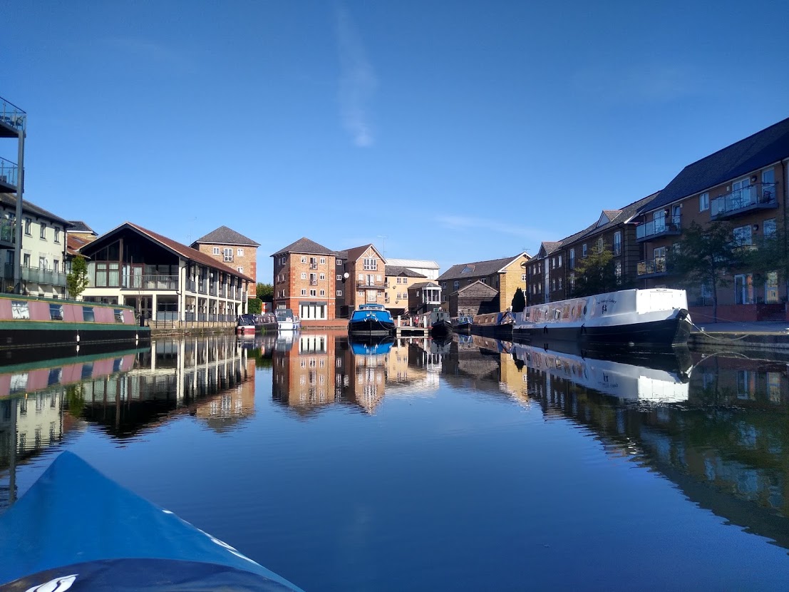
On a lovely sunny and lightwind weekday in early September, Dave dropped me off at Navigation Road in Chelmsford where there is a very unpromising public footpath down a short lane between Travis Perkins and a “light industrial” area that leads to the canal. Here, there is about 2m of grass canal bank that you can launch a kayak from. You can also pick up the towpath from here too. Having inflated and launched the kayak – I initially turned right to go into Springfield Basin itself and be purist about starting the journey properly at the start of the canal itself. Until fairly recently, this was derelict industrial wasteland – but it is now surrounded by new apartments and a lovely renovated basin with a few canal boats moored up.
A short paddle from the basin and you arrive at the first lock, Springfield Lock – also surrounded by plush apartments – some already built, some in the process of being constructed.
If you are walking, locks are dead straightforward. You just walk past them. Sometimes, you might have to switch over a bridge to the other bank. That’s it.
If you are in a kayak, it’s a bit more involved. You paddle up to the bank either before the lock gates or in the lock itself. You scramble onto the bank hoping that you don’t fall in and/or capsize your kayak or drop the paddle overboard whilst you drag both up on to the bank. You then drain out the kayak from where your paddling has been so splashy (although this might just be me). You then pick up the kayak and carry it along the length of the lock and to the other side where you will endeavour to launch it again. The canal is usually quite a drop down from the landing stage or canal bank which makes for an interesting launch and even more interesting “descent” of the crew into the vessel. Especially an inflatable one that will bend and fold when any weight is applied.
And whilst you can paddle 14 miles of canal and, for the most part, not meet any other boaters or walkers – people miraculously seem to appear at the locks so you will almost always have an audience, just in case you get it wrong and fall in. On this occasion, with people largely back at work and school, I was able to complete the first lock without an audience. I then paddled past the junction where the real river heads right into Chelmsford city centre – but as I did not fancy paddling up a weir, I chose not to go that way. Although I have since read there are plans to make this stretch navigable again which would enable boats to travel into Chelmsford City Centre again, so watch this space.
Instead, I continued left and passed under the road bridge that leads from Springfield and Chelmer Village to the Army and Navy and then passed through the Meads. This is a lovely stretch where you will have the canal to yourself and perhaps a few dog walkers walking the flood meadows hereabouts. The next stop is Barnes Mill Lock after which the canal passes through yet more beautiful scenery. When some lovely willow trees appear, you know you are approaching Sandford Mill Lock. A bend to the left takes you under an old brick bridge and into the lock itself, whilst the right hand fork passes round the channel and weir that used to power Sandford Mill. This is now a museum.
Sandford Mill Lock is where you will find a proper congregation of canal boats who call this home – along with Paper Mill Lock, Hoe Mill Lock and Heybridge Basin. You still have not really left Chelmsford and yet you feel like you are in the middle of nowhere – it is lovely.
The only downside of being in a kayak is that you are the same height or smaller than the swans that you occasionally meet. Swans are beautiful most of the time but seriously badass when they want to be – usually if they feel there is a threat to their territory or their young. When they put their feathers up and go for you – you don’t hang around.
Coming out of Sandford Mill Lock, I found myself behind a pair of swans gracefully paddling downstream in front of me. Whilst I wished they would hurry up a bit (I was getting hungry) I was happy to follow behind at a safe distance. After a while, they paused for a bit and then turned round and started paddling back towards me much more quickly. I kept close to the bank and they passed by with no difficulty. I then rounded the bend and saw why they had hesitated and then turned back. Two enormous swans were coming towards me at a great rate of knots and with their full “gangster look” switched on. I had found myself slap bang between a Swan Mexican stand off. So I did what the other swans did, turned round and paddled rapidly in the other direction. I figured if I paddled long enough for the offending swans to be off the others’ territory, I might not get caught in the cross-fire. I kept stopping to check but they kept coming and they were seriously fast! Eventually, they must have decided their honour was served and the feathers dropped back down a bit. So I risked turning round and paddling back past them. By then, they had lost all interest and were back to eating again so I was able to get past without issue. You don’t get that issue when you are walking on the tow path.
The next lock is Cuton Lock which is dominated by a large pill box – a reminder that our own river and county would have become a frontline battlefield if the Germans had got as far as landing on the beaches. Between Sandford Mill and Cuton, the canal passes under the A12 bypass and then runs parallel with it for a short while. The scenery is still beautiful though and its nice to be paddling along serenely, whilst others are having to scurry about in their cars. After Cuton Lock, the canal turns to the right and away from the A12 and it quickly becomes a distant memory and the subsequent Stonham’s Lock feels pretty remote.
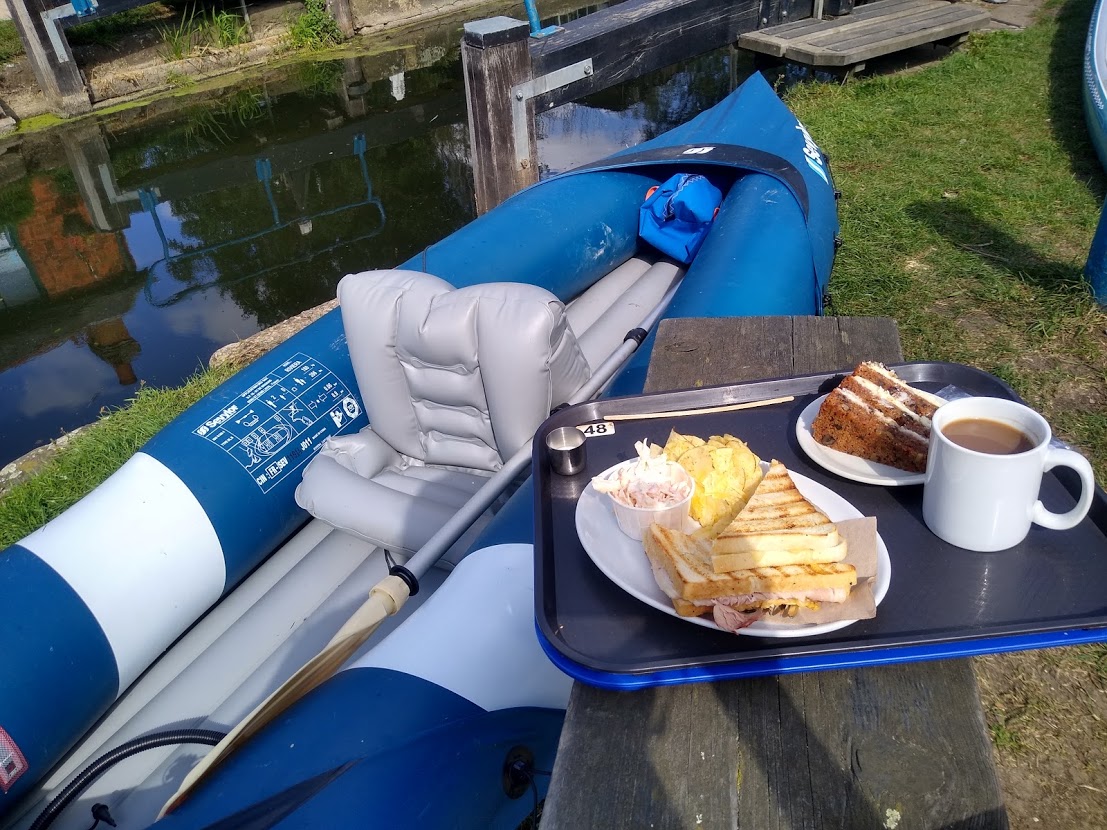
The next stretch brings you to Little Baddow lock and here you are likely to meet other river users as there is a road that crosses the canal with a small amount of unofficial layby parking available. This is one of my favourite locks as there is a lovely view across the weir to a beautiful country house – very picturesque. The next stretch brings you in to Paper Mill Lock – arguably one of the most well known locations on the canal, apart from perhaps Heybridge Basin itself. Paper Mill is home to a large number of canal boats both along the canal banks and in the marina behind the lock. It is also home to a fine tea room which is where I stopped for lunch. With a very large audience of people enjoying their lunch in the sunshine, I pulled out the kayak without entertaining them and berthed it by a small bench on the canal side. I had an excellent lunch followed by carrot cake and coffee – because that is what us sailors do – all the more enjoyable as the weather was so fine and the scenery so good.
Paper Mill Lock is roughly the half way mark on the canal and is well worth visiting by road too, if you don’t mind not having it to yourself. About ten minutes of paddling and you are back to the peace and quiet again, apart from a few walkers. Passing under a fairly high footbridge which inexplicably always seems to have young boys jumping off it even though the canal is on more than 4ft deep, you then reach Rushes Lock which is back in the middle of nowhere. This time, I was pleased to see an actual boat use the lock for its intended purpose, much to the delighted fascination of two walkers who had clearly never seen such a spectacle before.
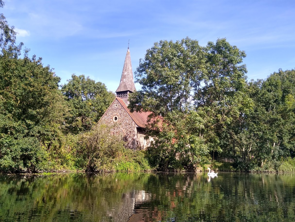
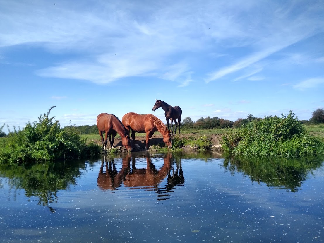
The next stretch round to Hoe Mill Lock is truly idyllic. The canal follows a left hand curve and you are paddling past a field where very fine looking horses graze right at the water’s edge. The canal then curves right and brings into view the stunningly beautiful Ulting Church, set right on the canal bank surrounded by trees. You have to pinch yourself that such a picturesque scene is real. A bit more paddling and you arrive at Hoe Mill Lock with more canal boats but sadly no tea room. This is another location where you are likely to meet people enjoying the canal or a picnic as it is crossed by another road. It was certainly busy at weekends in the summer with lots of people clearly trying their hand at kayaking or paddle boarding for the first time – a mostly positive upside to lockdown.
As before, it does not take long before you leave the busy lock behind and you are back on your own again – apart from a few people fishing. The next lock is Rickett’s Lock which has a lovely low brick bridge crossing the canal – although I cannot fathom where the road that use to cross here travelled from or to. There is certainly no road here now so I’ll need to take a look at some historic maps to work it out – on the current OS Map, they don’t even bother to give the name of the lock! The canal continues through fields and countryside, passing what is now the Langford Museum of Power outside Maldon.
The canal then brings you to Beeleigh Locks and its famous Weir. It is here that the River Blackwater joins the River Chelmer, having made its way from its source as the River Pant just east of Saffron Walden, winding its way through Braintree and round Coggeshall, Kelvedon and Witham before reaching Maldon. There are two lock gates here close together so you get to carry your kayak around two from the price of one and across the narrow bridge that passes over the impressive and historic Weir.
Once on the other side, it’s a short paddle until you reach the outskirts of Maldon. You pass under the A414 by-pass and then reach Tescos – without doubt the most anachronistic landmark along the canal! About ten minutes further on, if you are eagle eyed, the entrance to Heybridge Creek is just visible off to the right. The other end of the creek joins the River Blackwater east of the Fullbridge but unfortunately, you cannot paddle it because it has a big “Private” sign strung across the entrance and also the creek is blocked off about half way along by the sea wall. Someone has managed, however, to get a fully rigged and reasonable sized Dutch Barge parked just inside the creek from the canal. I have no idea how they got it there and even less idea why.
The canal briefly passes through the modern light industrial area of Maldon but it is not long before you pass under another road bridge at Heybridge proper and find yourself alongside the former Bentalls factory. This is impressive heritage building was built in 1866 for the Bentall family who were successful agricultural industrialists and also owners of some fine yachts and barges in their time. From here it is a straight line cut all the way to where the canal ends and boats could head out to sea from Heybridge Basin.
This final stretch has the largest collection of motor boats, narrow boats, yachts and the odd barge and many of you will be familiar with Heybridge Basin itself. If not, it is well worth a visit and has a large free car park, a coffee kiosk by the canal and two pubs and a Tiptree tea rooms overlooking the River Blackwater.
After fourteen miles of paddling, I climbed out and recovered my kayak for the last of the 12 locks. It was still a lovely warm and sunny afternoon and it was about an hour before high water. It dawned on me that once the tide was right in, I would be able to launch my kayak the other side of the lock gates without going up to my neck in Maldon mud. From there, I would have the ebb tide and a very light westerly breeze behind me all the way to Marconi and hopefully Bradwell. So I rang Dave to stop him driving to Heybridge in between his work meetings to pick me up as planned. He instead diverted to the sailing club and dialled into his remaining meetings from the van with a lovely view across Osea Island – that’s my idea of an office. Meanwhile, I sat in the sunshine enjoying a glass of wine and waiting for the tide to reach the extremely small patch of beach just below the Jolly Sailor. I recall we used to land here for lunch for our annual Jackpot race but could not work out how we used to park up our boats when we did!

Once launched again, I headed along Collier’s Reach and turned the corner at Northey Island before taking a straight line south east along the main channel of the River Blackwater and south of Osea Island. I reached Marconi Sailing Club in just over an hour. I have sailed that route several times much slower than that! After a brief rendez-vous with Dave at Marconi, I decide to press on to Bradwell Waterside although the sun was setting. Light was fading fast by the time I reached Stone and by the time I got in line with the Thirslet buoy, it was well and truly dark. Fortunately, there are sufficient lit navigation marks on the river (including Thirslet buoy itself) and my destination, Bradwell Waterside, was clearly visible due to the security lights at the marina.
My original plan was to find the channel behind Pewit Island which I figured would still be navigable at this state of the tide and a shorter journey. In daylight, this would have been perfectly feasible. However, at night time, the mud, river, land and sky were indistinguishable so although I knew exactly where I was, I could not see enough to find a route across or behind the mudbanks.
So the only option was to go the long way round and follow the main river nearly as far as the Baffle and then turn right into the buoyed channel into Bradwell. It was slightly frustrating as the Marina lights were so clear and I could also see the lights of Dave’s Transit van parked at the top of Bradwell slipway waiting for me! But paddling along in the dark is quite magical. Apart from trying not to bump into a Pewit Island – the navigation lights for Radio Caroline, Thirslet, the baffle and various lights at Tollesbury, West Mersea and Stone give you a reassuring understanding of where you are.
I reached the flashing white beacon that marks the entrance to Bradwell Creek and then picked up the first port hand channel marker that is helpfully lit. I only bounced off one withy that jumped out in front of my and then kept an eye out for the starboard marker in the corner of Bradwell Creek which is also lit. I was punching the tide now so for the first time had to work quite hard to make proper progress. A short paddle later through the moorings and I landed at the end of the concrete slipway – ironically made harder to locate as it was dazzled with the full beam of a Transit van.
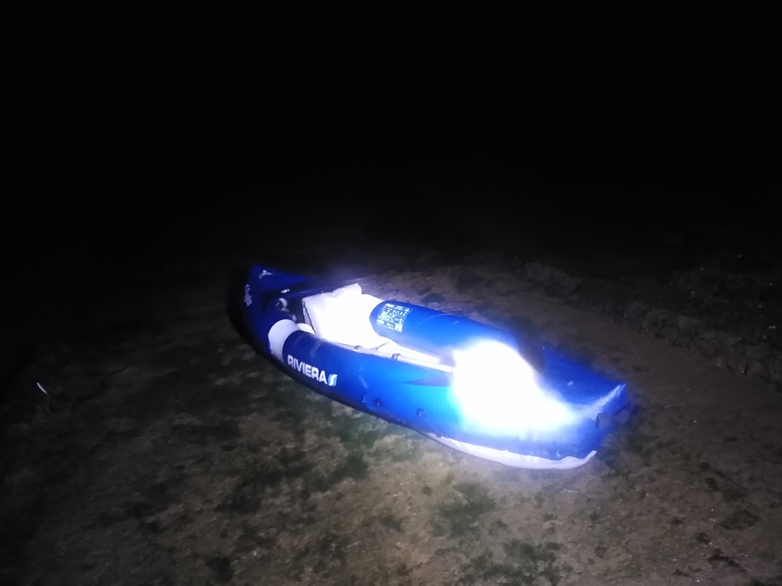
I carried the kayak for the last time up the slip. Having deflated and packed it away, I got changed in the van and then celebrated my epic 24 mile journey with a large glass of wine in the Green Man, just up the road.
If you would like to walk or paddle the canal – public parking is available in Chelmsford city centre, Paper Mill Lock and Heybridge Basin. There are no public conveniences along the route – although customers of the tea rooms and pubs at Paper Mill Lock and Heybridge Basin can use their facilities.
The tow path is clear and easy to follow but is prone to a bit of mud in places following prolonged wet weather. And I would always advocate wearing a lifejacket whilst afloat. I have heard several canal users say “oh, its only four feet deep”. That is, however, based on the assumption that you fall in the feet first. As we sailors know, that is rarely the case and you never quite know what is under the surface. Having said that, it is a very safe environment to take to the water – apart from the gangster swans.
To buy a licence, visit Inland Waterways – https://www.waterways.org.uk/waterways/sites/essex-waterways/things-to-do/canoeing-paddleboarding
To find out more about the Chelmer Canal Trust and support their work – visit: www.chelmercanaltrust.co.uk
Thank you to Jenny Ball for providing this write up of her adventures.